 Kevin Lidtka is a Laser Scanning Technician at City Light, a title that might make it sound like he works on office equipment. That perception couldn’t be further from the truth.
 Kevin Lidtka is a Laser Scanning Technician in City Light’s Power Production division, a title that might make it sound like he works on office equipment. That perception couldn’t be further from the truth. In fact, Kevin is in a one-of-kind position at the City of Seattle; he uses lasers to produce 3D images of physical environments.
Kevin got his start in laser scanning by working as a land surveyor at a private engineering firm for eight years before joining the City. He’s been at City Light for four years now, and in that time he’s put his laser to use on many projects.
In this week’s Seattle City (spot)Light, Kevin tells us how he got into laser scanning and exactly how it works.
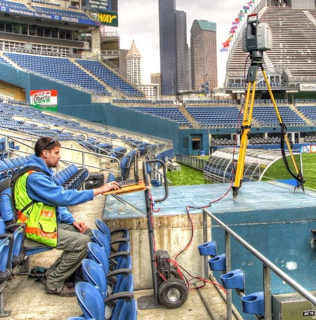
Laser Scanning Technician Kevin Lidtka
“I got into surveying because it was outdoors and it seemed like an exciting thing to do; it’s not a cookie-cutter job. I was working as a surveyor out the field when I saw my first laser scanner, and thought it was the coolest thing I had ever seen. Today I map City Light’s assets with a 3D laser scanner, which is a survey tool that accurately maps everything its sees within a thousand feet.”
“The scanner sits on a tripod because it is a big heavy piece of equipment. It’s like a camera, I suppose… And calling it a 3D camera is the easiest way to explain it. I really enjoy photography and art, and the same eye for composition that you need for photography is what’s needed for laser scanning. Everything you can see, it sees,” said Kevin.
“The scanner shoots a laser beam out and spins it around with a mirror. It’s just a single line, but that line maps every surface that it touches with a single point. Those points create a 3D point cloud.”
“Once it’s done scanning, I drop the point cloud into a computer program where you can look at it. You can view the scan in 3D and spin it all around, zoom in and out and examine things all the way down to one millimeter. This is useful in all sorts of ways.”
“For example, I’ve been going to Boundary Dam for four years now. Over time, I’ve built a point cloud of all the facilities there. Since it has about a millimeter accuracy, we know the exact dimensions of every space. If they want to add a building, they know what to avoid. If they need to move equipment, they know their clearances. It’s perfect for any task which calls for the knowledge of what fits where.”
“Here’s another example: In the last four months, I’ve set up at the exact same spot every time I visit Boundary to get a really good vantage of the face of the dam. I scan the face and then overlay that data with the last version. Over time, this will tell us how the dam expands when it’s really hot or contracts when it’s really cold. We will be able to animate the data and watch the dam ’breathe.’ That data goes to the Dam Safety group, of course.”
“It takes someone willing to think outside of the box to jump onboard with laser scanning. It’s a powerful tool, and City Light has given me the platform to produce some amazing things. Laser scanning is starting to become well-known, and I imagine in the future it is going to be in even greater demand.”
If you want to find out more about Kevin Lidtka or laser scanning, read Kevin’s posts at xyHt magazine or visit his YouTube channel to see animated scans.