Boundary Hydroelectric Project from its Vista House
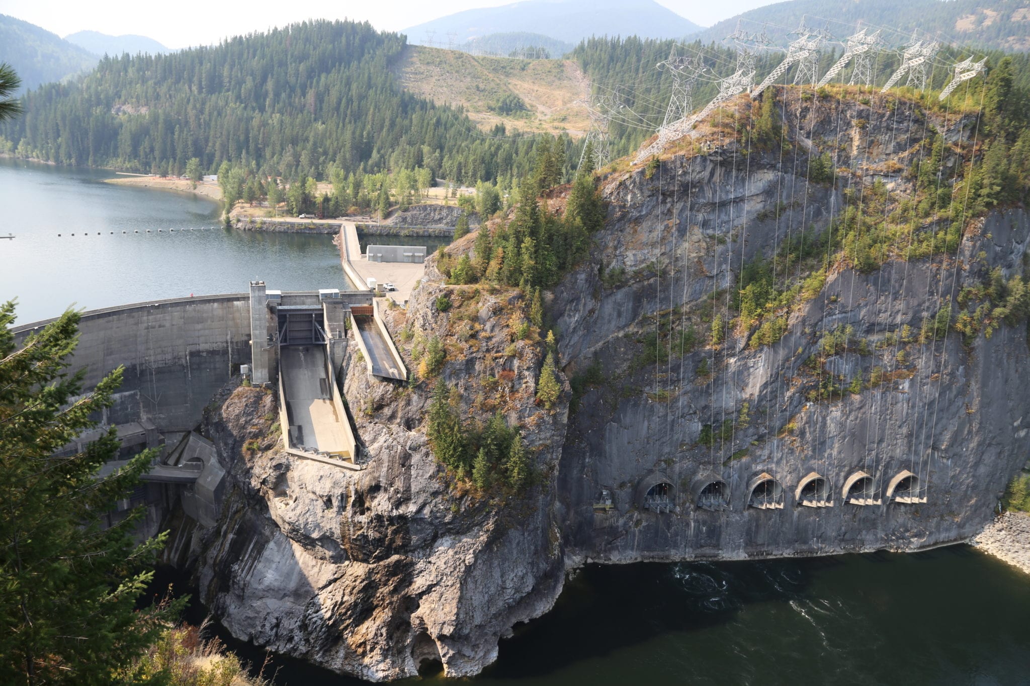
For more than 50 years, the Boundary Hydroelectric Project has powered Seattle with its clean hydropower. At 340 feet tall, the concrete double-curvature arch of Boundary Dam cuts an imposing figure on the Pend Oreille River in northeastern Washington. In January, City Light submitted an application to the Washington Department of Archaeology and Historic Preservation for Boundary to the National Register of Historical Places. Today, the Advisory Council on Historic Preservation determined that Boundary meets the National Register criteria.
“Determining the Boundary Project’s eligibility for the National Register is a requirement of our license to operate the dam, but to be listed on the National Register is an honor,” explains City Light’s Mike Aronowitz. “It’s confirmation that the history and design of Boundary deserve to be nationally recognized and preserved.”
The nomination will now be sent to the Keeper of the National Register within the National Park Service, who makes the final listing decision.
ABOUT THE BOUNDARY HYDROELECTRIC PROJECT
City Light announced its plan to acquire the Boundary Dam site and construct a hydroelectric power plant Oct. 27, 1953. On July 10, 1961, City Light was issued a license by the Federal Power Commission, granting the utility permission to utilize a section of the Pend Oreille River and construct Boundary Dam. Construction began in August 1963 by carving out 500,000 cubic yards of the limestone mountain to make way for the world’s largest underground powerhouse at the time. The machine hall, which houses the turbines that generate electricity, was excavated to be 477 feet long, 76 feet wide and 15 stories below the ground. The dam itself was built to an astounding 340 feet tall, 32 feet at its base and eight feet at its crest. The reservoir that retains the water from the Pend Oreille River is 1,794 acres and 17.5 miles long, roughly three times the size of Lake Union.
The 1,040-megawatt Boundary Hydroelectric Project (Boundary Project) impounds the Pend Oreille River in a rural canyon north of Metaline Falls, in Pend Oreille County (pronounced Pon-deh-RAY), Washington, and is owned and operated by Seattle City Light (City Light) under Federal Energy Regulatory Commission (FERC) License No. 2144. Completed with four generation units in 1967, the multi-component facility was built between 1963 and 1967 and consists of a concrete variable-radius, double curvature, thin arch dam, an underground powerhouse, the Vista House, and other support and recreation-related built resources as were developed during the original construction period. The overall nominated district covers 167 acres, all located within the larger boundary for the FERC license.
The Boundary Project is located at river mile 17 on the Pend Oreille River in a narrow canyon in the Selkirk Mountains, in northeastern Washington, about ten miles north of the Town of Metaline Falls and one mile south of the U.S.-Canada border. Boundary is a multi-component project occupying 167-acres within the larger licensed area, and is operated by Seattle City Light under FERC License No. 2144.1 The individual resources of the Boundary Project were designed by multiple engineering firms and architectural firms as detailed below, under the direction of Herbert V. Standberg, City Light’s project engineer, with Cr. Hoidal and Robert L. Skone providing, respectively, civil and electrical engineering oversight.
The Boundary Project is documented as a “district” which includes the dam, forebay, powerhouse, transmission line, Vista House, and related recreational and support structures, tied together by the original looped road system from the controlled access point at the end of Boundary Road.
In 2013, City Light was issued a new license to operate Boundary through 2055. With the new license comes several important recreation developments that will directly benefit the local community and promote economic development. Improvements are already underway at the Forebay Recreation Area. Other enhancements are slated for Metaline Waterfront Park in 2018, followed by two new spectacular viewing locations and a portage trail for kayakers around Metaline Falls in 2019. A new hiking trail on the east side of the reservoir will be added in 2020.